
Travels
Related posts Nov. 22 and 26.
Today is the return trip after Thanksgiving. Despite warnings around Covid-19, many travelled, now returning home. This seems a good day to reconstruct some travel in the old days, and this U.S. map, in a ca 1941 Shell Oil road map of Iowa, show the U.S. in those days (a pdf is also included below). I’ll focus on my own family research.
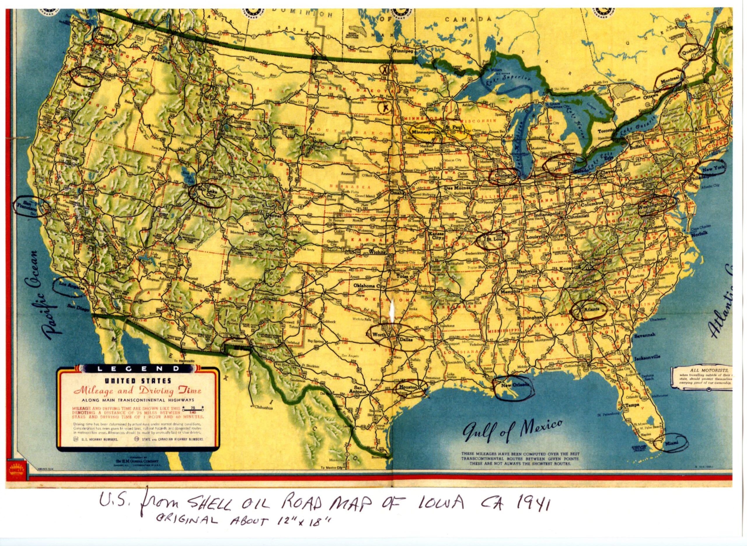
U.S. Map on Shell Oil road map for Iowa ca 1941. Pdf of this Map: U.S. Map ca 1941 Shell Oil (click to enlarge)
Traveling has always been a part of the life experience of immigrants. All of my ancestors were immigrants to North America, the French side to Canada in the early 1600s; the German side to Wisconsin territory in the 1840s.
My first family reaching the Twin Cities (Bernard side) reached what is now the Minneapolis area (Dayton MN) somewhere around 1854, with six children in tow, from about ages 3 to 16. My great-grandmother, was then about 5 years old, the second youngest. Exactly how they came from eastern Ontario will forever be unknown. Railroad did not reach this area until 1867; early roads were very primitive; riverboats did come up the Mississippi for those who could get to embarkation points downriver. Doubtless there was lots of walking, but that would be an incredible task, particularly from home in eastern Canada with several young children.
I know my grandparents Bernard took a major trip home to Quebec in 1925 almost certainly by train from Winnipeg, ending at Quebec City. I have their photographs from that trip.
In 1934, my Aunt Josie moved west from Grafton ND to Los Angeles. In 1939, living in Los Angeles, she made a major trip with friends to a Convention in Toronto. It is possible that a reason for this trip related to Josie’s husbands death after a surgery. They had been married only two or so years. Years ago she gave me the AAA Road map which the group kept, which I adapted to simplify here: Josie Bernard trip 1939001. It is a one page pdf with explanation (click to enlarge). Josie was near life-long deaf, and the Convention was of an insurance company catering to deaf clients. So, even in those days, there was mobility, certainly not to todays standards, but not unknown either.
In 1941, my Busch grandparents made a driving trip from North Dakota to rural Wisconsin, near Dubuque, the probable reason for the Shell Oil road map that is the source of the U.S. map above. Family photographs revealed the reason for the trip. Grandma’s sister, her maid-of-honor at her wedding, Julia, was in the end stages of ALS (Lou Gehrigs disease), and this was a sad family reunion. Julia died the next year, at about age 60.
Also, in 1941 as a one year old, I took my first long trip, from North Dakota to Long Beach California by car with my parents and grandparents. It was on this trip that I met my Uncle Frank on shore leave from the USS Arizona, five months before he died at Pearl Harbor. Dad’s writing recounted the route west. A few postcards sent home to the Busch’s reveal that my parents and I came home via the west coast highway thence east from Oregon or Washington.
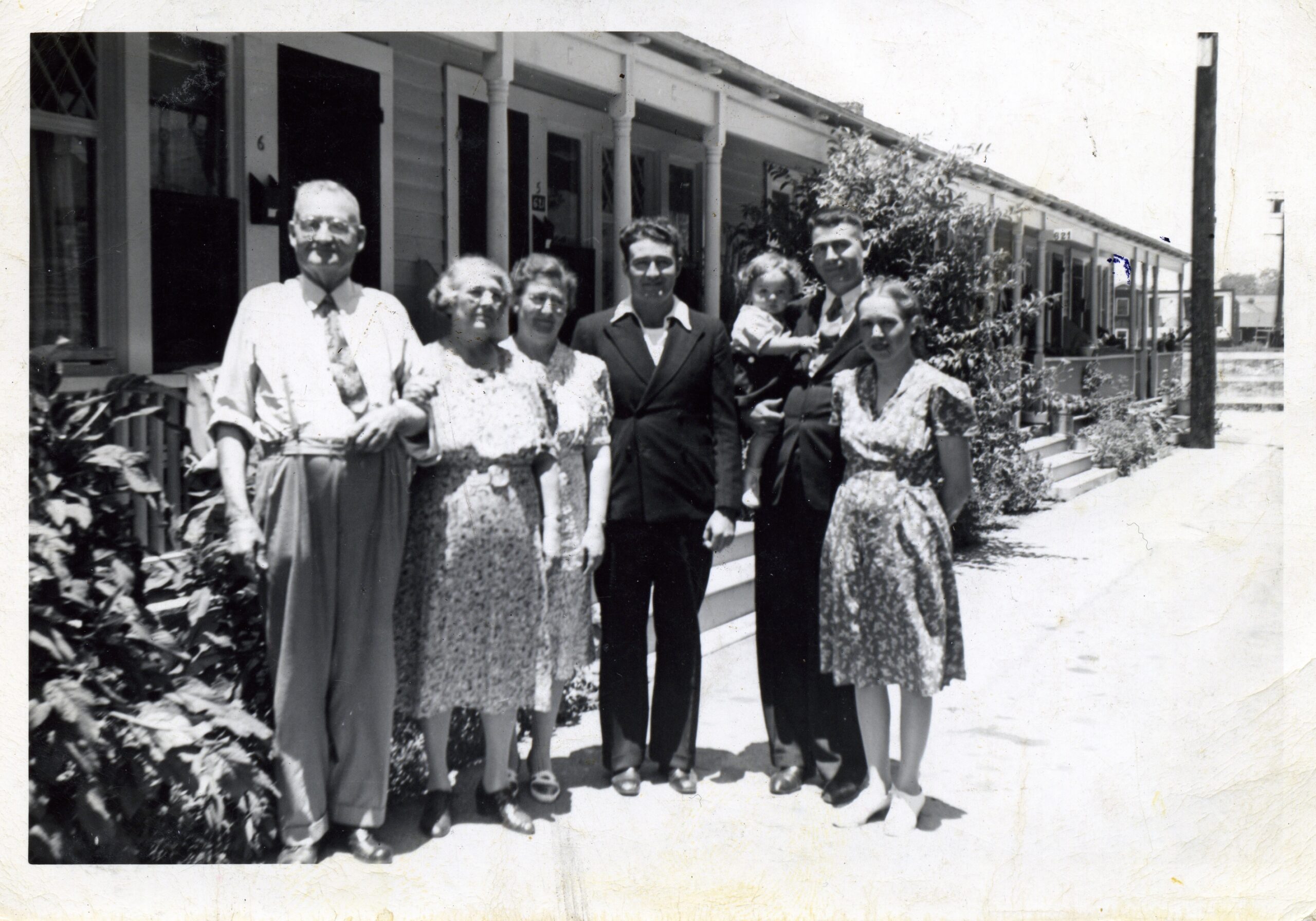
Late June 1941, Long Beach CA, from left: Henry and Josephine Bernard, Josie Whitaker, Frank Bernard, Richard, Henry and Esther Bernard.
There were other similar trips, but they were pretty rare and on particular occasions. The Busch’s probably went by train to Ft. Wayne IN for their youngest sons wedding in January, 1955. The next month was their own 50th anniversary. And so on.
But leaving the farm was not a routine matter. There were cows to milk, just for one example.
The 1941 Shell Oil map also reveals the radio stations possibly accessible on road trips, so car radios were not unknown. Here were the midwest radio stations on the Shell map. Midwest Radio Stations ca 1941.
But travel was not luxurious. My memories begin when I was about 4, a year or so before the end of WWII. I remember the trips as a kid would.
Those old cars were simply a device to get from point A to point B. No seat belts, air conditioning, etc., etc., etc.
Now memories of the old days for a now-old-timer!
Another interesting insight into the previous generation’s way of life, Dick. Thank you!
I’m particularly fascinated by older roads and older maps. My typical way of traveling is to use what I laughingly call “death by GPS”, in which I just put the designation in, and if the alternate route isn’t too outrageous I’ll typically take it – and continually modify it along the way. Good chance to see a lot of older dying towns and older roads that way!
Come to realize that it’s partially the interstates; but the much more reliable automobile that has led to the decline and fall of small town America. I am particularly reminded of that every time I drive up to Lake Tahoe, which these days it is today about five a two hour trip. Even 50 years ago, it was at least a half a day or longer trip, which led to the pop-ups of numerous hotels, restaurants, service stations and the like along the way – it was necessary then. Most of them these days are just a (literally in some cases) a burned out shell.
This phenomenon is particularly evident along the old route of US 66, which I’ve more or less paralleled the last couple of road trips. There are lots of old roadside attractions that no longer attract people and are no longer even needed because people can just bypass with their very reliable cars on the very reliable interstate.