Dick Bernard: The Korean Peninsula and Poland, very briefly…
Book recommendation from Marie: A book you might be reading is: Age of Anger A History of the Present by Pankaj Mishra.
*
Hubris always ends badly*.
This date the great meeting with Vladimir Putin and Donald Trump occurs in Hamburg. The only U.S. representative with Trump will be Rex Tillerson, Secretary of State. Yesterday, Trump gave a major speech to an invited audience in Poland. In the same time period North Korea successfully launched an ICBM which signalled its capacity of delivering a nuclear warhead as far as Alaska.
I’m an old geography major, old enough to have had my college degree a year before I was sitting in an Army barracks in Oct 22, 1962, watching President Kennedy tell we Americans about the Cuban Missile Crisis where Russia was said to be delivering ICBMs whose range was as far as Cheyenne Mountain, below which I was sitting near Colorado Springs Colorado.
It seems a good time for a tiny briefing about Poland and Korea….
KOREA.
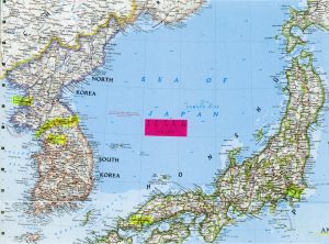
(click to enlarge)
Note especially the red rectangle at center in the map. That rectangle is about 125 miles wide, giving an idea of the scale of the map. Note Seoul, and Pyongyang, and Tokyo and Hiroshima, all hi-lited in yellow, as well as the 38th parallel, the demarcation between the two countries** since the end of what has come to be known as the Korean War (though it was never a declared war).
The Korean peninsula is not a place for a “loose cannon” on any side…. Note the CIA Fact Book about both North Korea and South Korea. For comparison, Minnesota has a population of about 5 1/2 million; N. Korea about 25 million, S. Korea about 51 million. In land area, N. Korea is slightly larger than the state of Virginia; slightly smaller than the state of Mississippi; S. Korea is a bit smaller than Pennsylvania, a bit larger than Indiana.
Google Maps notes that you can’t get from Seoul to Pyonyang by road. Still the map is interesting. And a guided missile is a very short trip away from both in the area of the 38th parallel. Tokyo and the rest of Japan are not that far away, either. Here’s the Japan briefing book from the CIA.
POLAND.
If there was ever a place for a white nationalist to give a speech, it would be Poland. Here’s the CIA Factbook on Poland. Poland has not been treated kindly by history: Napoleon, Hitler, Stalin….
I have been to Auschwitz, Krakow, Czestochowa and Gdansk (2000 and 2003).
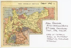
My grandmother was in 8th grade in about 1896 when she learned the geography of Europe. Here is the map from her textbook which shows Europe as it existed then. Most interesting to me is that this map, from a standard text for American Catholic Schools at the time, does not even name Warsaw, already a major city**.
As we learned when we visited Auschwitz in 2000, Auschwitz (Oswiecim in Polish times) was basically a prison camp for 140-150,000 Poles, about half of whom died; adjoining Birkenau was the extermination camp for the Jews. Nearby was a third forced labor camp, Monowitz, part of the I. G. Farben Buna factory (from the book “Auschwitz, Voices from the Ground” purchased at Auschwitz, May, 2000).
Pope John Paul II, the “Polish Pope”, born in 1920, grew up in nearby Wadowice, Poland, and thus felt the full impact of both Nazi Germany and Stalinist Soviet Union. His world view was likely shaped by his experiences.
I remember, from the time of our visit, that perhaps 10% of Poles fell as victims of WWII; as well as virtually all of the Polish Jews. (Note here.) Of all countries, Poland was among the most devastated by WWII.
On the other hand, our dear friend, Annelee, who grew up in Hitler Germany, lost her Dad to the war. He was a conscript who refused to become a Nazi, though he would have benefited from such a move. They are not sure where or when he died, though it was likely in Russia. They lived in terror of being taken over by the Russians after the war (they weren’t).
* “Hubris”? Some time back I was giving a ride to my friend, Joe, a retired distinguished international emeritus professor at the University of Minnesota. The car conversation got around to Napoleon and Hitler’s misguided attempts to control all of Europe and Asia, attempts which failed. “Hubris” is how my friend defined their actions. In a different sort of way, yet very similar, Donald Trump is trying to translate a slogan into action: “Make America Great Again”, but I think the world leaders are a bit wiser now. This won’t stop the macho coffee conversations about “kicking ____’s ass” (fill in the blank with whomever or whatever the target of choice might be.
There has never been a good time for hubris. Most certainly not now, when we are a global society, with the capacity to destroy ourselves.
It is time for cooler heads everywhere to prevail, one person, one conversation at a time.
Back to you.
Comments welcome to Dick_BernardATmsnDOTcom.
Another map from the same 1896 text. Click to enlarge. Note that Moscow is not even mentioned.
** – Note comment from anonymous below.
COMMENTS
from Jeff: Old maps are interesting. My German grandparents on my mothers maternal side emigrated from Pomerania, which was then part of Germany, is now part of Poland. I think it was originally East Prussia , which eventually became Germany under Bismarck. A majority of the people in Pomerania were German , some had Polish surnames but were Germans. The maps of Asia are more interesting… Iraq doesn’t exist as it was part of both the Ottoman empire and Persia. Syria didn’t exist, and look where the Ottoman empire extended around Arabia encompassing Israel, Palestine, Jordan the Gulf emirates, parts of Saudi Arabia. Vietnam was a colony of France, India, Burma, Malaysia, Singapore a part of the British Empire…..
Response from Dick: Indeed. Most of us have only the thinnest veneer of knowledge about the world as it was or is, even our own country. It makes for problems…and opportunities for people who benefit from simplistic notions of superiority or such. One of my vivid memories from the trip to Poland was at the Krakow Cathedral in early May, which I think was Constitution Day or such in Poland. There was a Mass there, and after Mass, one of the people we met was an ancient man (WWII vintage) wearing very, very proudly his Polish Army uniform. I should dig out the slide. It was just an old Army uniform, festooned with whatever decorations he had received ‘back in the day’.
“Tribes” are useful, and sometimes important, but more often than not dangerous. A friend gave me a CD by a superb Irish Tenor, including assorted songs, mostly of lament. One which sticks especially is “The Band Played Waltzing Matilda”, about an Aussie who encounters the Turks (the Ottomans) at Sulva Bay in Gallipoli is WWI. Listen to it here.
A year or so ago we went to the Russia Museum in Minneapolis to see the exhibit on WWI from the Russian perspective. One caption I remember quite vividly. Apparently, the Kaiser and the Czar were first cousins, the German and the Russian rulers. And apparently WWI really started with some argument over something or other. This was before the assassination….
from Jeff: Actually the Kaiser, the Czar, and the King of England were all cousins… It wasn’t that long ago either.
from Fred: Very well put. Excellent idea to use a little geography and cartography to assist the uninitiated.
from Terrance: I have been amazed over the past 25 years since the fall of the Soviet Union how little we learned from the Catholic textbooks about how many people from various little nations, religions and ethnic backgrounds were forced into the USSR. If they weren’t Catholic, they were dismissed in our Geography classes as irrelevant.
** from Anonymous: I read your blog about Poland and Korea and agree with you that we Americans need to be better informed about both. But may I offer a few critical comments?
You stated that “the 38th parallel, [was]the demarcation between the two countries since the end of what has come to be known as the Korean War.” That is not correct. The 38th parallel was the the boundary from the end of WWII until the start of the Korean War. The de facto boundary since that war has been the cease-fire line at the time of the truce which ending the fighting (in 1953). That line was to the north of the 38th parallel in its eastern sector and to the south in the western sector. (In 1980 I crossed it to visit a national park in what passed from North to South Korea in 1953.
The blog was interesting.
from Norm: Great observations and commentary, Dick.
I am not an old geography major albeit old I am. On the other hand, I am and have always been a geography buff going way back to my early introduction to them in National Geographic. I have always loved maps of areas ranging from those of a township to a state to the nation and to the world, whatever their purpose but mainly that show geographical features and political boundaries although the latter change frequently in boundaries, name and existence.
I served nearly four years as a USAF photo radar intelligence officer which was later categorized by the folks in the public sector when describing my work history as that of a cartographer which it essentially was in many cases.
I have always been intrigued as well by how natural geographic features such as rivers, mountains, large lakes and so on can affect the politics of things. For example, the folks on the leeward side of the mountain range having different political views and customs let alone cultures than those on the windward side of the range or on the other side of the river or large lake or whatever.
That is just very interesting to me, Dick.


