#1099 – Dick Bernard – Hawaii, more history with the U.S. than we think….
Previous posts at January 6 and January 11. Other posts will follow.
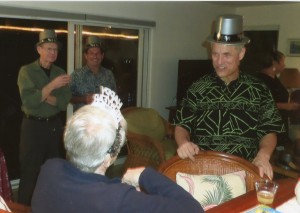
New Years Eve we were seasoned veterans of the Big Island. It was our 12th day at the Kaawihae Village house…and there was a New Years Eve party, with real Hawaiians there!
It was a relief to find that real Hawaiians were just folks, like Cathy and I. We all acted our age; quite a few celebrated New Years when Los Angeles did (two hours earlier) and bid aloha.
Very unusual for me, I stayed up till midnight, the real midnight, but not long after.
2016 was here.
I have a long time interest in geography – it was my major in college. Even so, it is always interesting to match up preconceptions with realities, physical, human, etc. For starters, the island of Hawaii is not flat, like a regular map suggests. Sure, we know the highest mountain in the world is there (if measured from base to top, Mauna Loa is over 30,000 feet), but even above sea level it is just a few hundred feet less than Pike’s Peak, but not a dramatic sight from anywhere within the roughly 30-50 mile radius of the Big Island.
Basically, Mauna Loa and its twin Mauna Kea are the island of Hawaii.
For some reason, Hawaii feels and even sounds like a foreign country, even though it is every bit as American as anywhere else in the U.S.
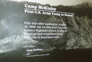
A poster at the Army Museum at Waikiki Beach summarized the U.S.-Hawaii history as follows:
Succinctly, Hawaii has been in the U.S. sphere for many years.
118 years ago, in the early summer of 1898, my grandfather Bernard and his fellow soldiers likely arrived at what is now Hickam Field at Pearl Harbor as their ship likely refueled enroute to Manila and the Spanish-American War [see end note]. They were there before Hawaii was formally annexed by the U.S.
This happened a few months after their miserable troop ship steamed out of Pearl Harbor. And that was quite a long time ago. A sketch history of Hawaii is here.
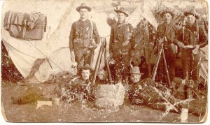
Henry Bernard, upper left, at Presidio San Francisco, Summer 1898; his future wife’s cousin, Alfred Collette, is at lower right.
Sadly, 43 years later, Grandpa’s youngest son, Frank, went down with the Arizona at Pearl Harbor….
At the gathering on Dec. 31 were many nice people, including an announced candidate for the Hawaii State Senate, by all appearances a very capable guy.
He and his family were neat people: his district would be fortunate to have him again as their Senator.
But that is ahead.
Back home I got to thinking about a photo I’ve long had, which I hadn’t paid much attention to.
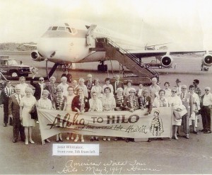
That’s my Aunt Josie, Grandpa and Grandma’s daughter, and Dad and his brother Frank’s sister….
She’d beat me to Hilo 47 years ago.
Josie was part of the Los Angeles deaf community, and my guess is that everyone in the photograph was deaf, part of a tour group to Hawaii.
Aloha. Mahalo.
End Note: In a rather quick review of the literature on the internet, I don’t find any specific information about the troop ships going from Presidio San Francisco to Manila in 1898, except that the trip was well over a month in duration; and I had previously heard that they stopped at Honolulu enroute. Folks I talked with in Honolulu were short of specifics, though one man at the Army Museum was sure that the fueling station would have been where Hickam Field now is. A research task for another time.
[contact-form to=’dick_bernard@msn.com’][contact-field label=’Name’ type=’name’ required=’1’/][contact-field label=’Email’ type=’email’ required=’1’/][contact-field label=’Website’ type=’url’/][contact-field label=’Comment’ type=’textarea’ required=’1’/][/contact-form]


Leave a Reply
Want to join the discussion?Feel free to contribute!